
Anúncios
Ask people to name the brightest star in the sky and many will say the North Star.
It is a common mix-up. Polaris is only moderately bright,
yet it has guided travelers for centuries for a different reason: it barely moves while the rest of the sky turns around it.
Anúncios
Below you will learn several reliable ways to find Polaris,
how to use it to find true north and estimate your latitude,
why it will not be the pole star forever, and what observers in the Southern Hemisphere use instead.
What Makes Polaris Special
Earth spins on an axis, and if you extended that axis out into space from the North Pole,
it would point to a spot called the north celestial pole.
As the planet rotates, every star appears to wheel around that spot once a day.
Polaris happens to sit less than one degree away from it, so it looks almost perfectly still.
Its brightness is similar to the main stars of the Big Dipper,
which means it is easy to see from a suburban backyard but not dazzling.
Polaris is actually a luminous supergiant several hundred light-years away, and it varies very slightly in brightness, though far too little to notice by eye.
For practical purposes, what matters is its position, not its glow.
One important limit: Polaris is a Northern Hemisphere star.
From the equator it sits right on the horizon, usually lost in haze, and from anywhere south of the equator it never rises at all.
Find It Using the Big Dipper
The Big Dipper, a seven-star pattern within the constellation Ursa Major, is the easiest route to Polaris.
From Canada, most of Europe and the northern half of the United States it never sets, though its position changes with the time of night and the season.
It can stand on its handle, hang upside down above Polaris or sit low near the northern horizon on autumn evenings.
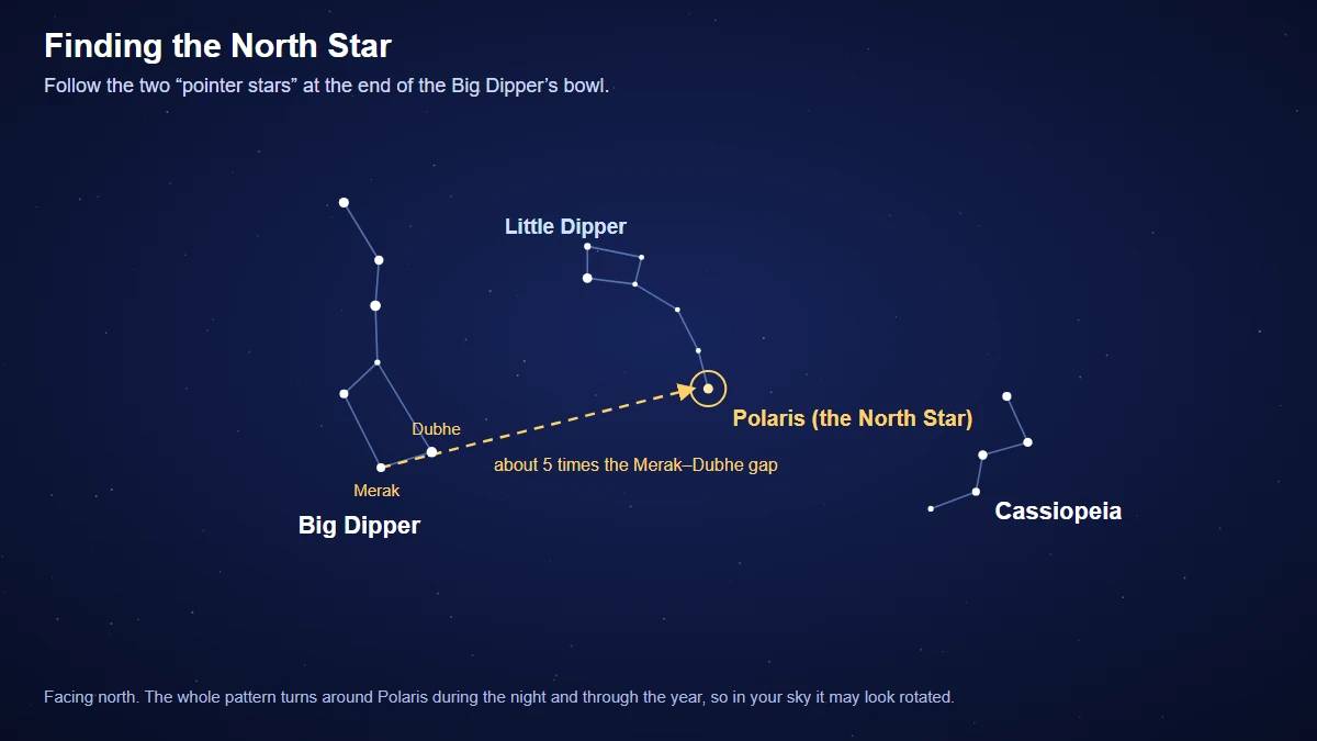
- Face roughly north and find the Big Dipper, a bowl of four stars attached to a curved handle of three.
- Locate the two stars that form the outer edge of the bowl, farthest from the handle. These are the Pointers, Merak at the bottom of the bowl and Dubhe at the lip.
- Draw an imaginary line from Merak through Dubhe and keep going out of the open side of the bowl.
- Extend that line about five times the distance between the two Pointers.
- The first moderately bright star you reach, standing fairly alone, is Polaris.
The line works no matter how the Dipper is oriented, because the Pointers always aim toward the pole.
If you end up at a noticeably brighter star, you have probably overshot or drifted sideways, so try again with a steadier eye.
Two Backup Methods
Use Cassiopeia
When the Big Dipper sits low and is hidden by trees or buildings, look for Cassiopeia,
a bright W or M shape on the opposite side of the pole.
Polaris lies roughly halfway between Cassiopeia and the Big Dipper, and a little closer to Cassiopeia than many beginners expect.
Because the two patterns sit on either side of Polaris, one of them is always well placed.
Trace the Little Dipper
Polaris marks the end of the handle of the Little Dipper, part of Ursa Minor. The Little Dipper is faint,
and under city lights you may only see Polaris and the two stars at the end of its bowl,
sometimes called the Guardians of the Pole.
Under darker skies, tracing the full pattern is a good way to confirm you have the right star.
Measure Your Latitude With Polaris
Here is where Polaris becomes genuinely useful.
In the Northern Hemisphere, the height of Polaris above the horizon, measured in degrees, is roughly equal to your latitude.
At the North Pole it would be straight overhead at 90 degrees; at the equator, it would sit on the horizon at zero.
You can estimate this with your hand. Held at arm's length, a closed fist covers about 10 degrees of sky.
Stack fists from a flat horizon up to Polaris and count.
Someone at 40 degrees north will need about four fists.
It is a rough measurement, but sailors used the same principle with precise instruments for centuries to find their latitude at sea.
This also explains why Polaris feels so high in the sky from northern Scandinavia and so low from southern Florida or the Canary Islands.
The farther north you go, the higher it climbs.
Finding North Without a Compass
Once you have Polaris, drop an imaginary vertical line straight down to the horizon.
That point is very close to true north, the direction of the geographic North Pole.
Face it and east is on your right, west on your left and south behind you.
Keep in mind that a magnetic compass points to magnetic north, not true north.
The difference, called magnetic declination, depends on where you are and slowly changes over the years.
Maps often note the local value.
Polaris gives you true north directly, which is one reason it remains a favorite check for navigators and surveyors.
Treat the star as a backup, not a replacement for proper navigation.
Clouds can hide it at the worst moment, so anyone heading into remote country should carry a map,
a compass and the skills to use them.
What About the Southern Hemisphere?
The south celestial pole has no bright star to mark it.
The nearest naked-eye star, Sigma Octantis, is so faint that it is hard to see without a dark sky.
Southern observers instead use a combination of patterns:
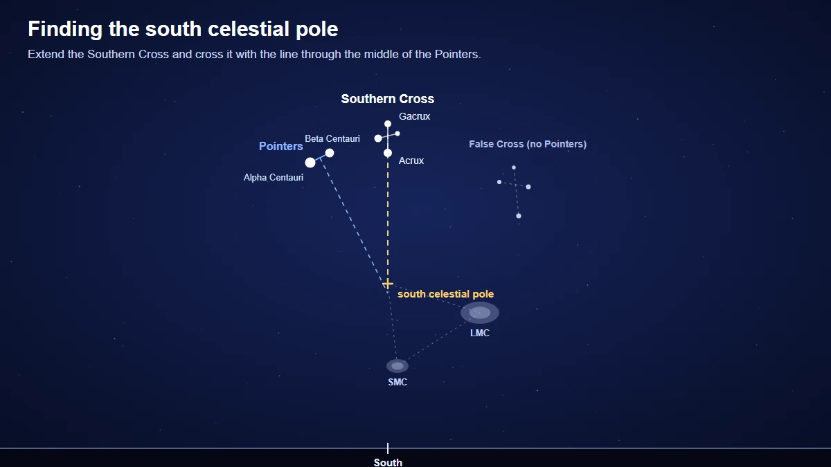
- Find the Southern Cross, a compact kite of four bright stars, and imagine a line along its long axis, from the top star through the bottom star.
- Extend that line about four and a half times the length of the cross.
- Find the two bright Pointers, Alpha and Beta Centauri, beside the cross. Imagine a line joining them, then a second line crossing it at a right angle through its middle.
- Where that second line meets the extended axis of the cross is close to the south celestial pole. Drop straight down to the horizon for due south.
Watch out for the False Cross, a larger and fainter cross-shaped pattern nearby.
The real Southern Cross is smaller and brighter and always has the two Pointers next to it.
From dark sites, the Large and Small Magellanic Clouds also help, since they form a rough triangle with the pole.
A Pole Star That Changes Over Time
Polaris has not always been the North Star, and it will not keep the job forever.
Earth's axis slowly wobbles like a spinning top, tracing a large circle in the sky over roughly 26,000 years.
This motion is called precession.
Some 4,500 to 5,000 years ago, around the era when Egypt's great pyramids were built,
the star nearest the pole was Thuban, a modest star in Draco.
Polaris will keep edging slightly closer to the pole for about another century before slowly drifting away.
In roughly 12,000 years, brilliant Vega will lie near the pole, though not as close as Polaris does now.
Why Astronomers Still Use It
Polaris is more than a historical curiosity.
Anyone who owns a telescope on an equatorial mount lines up the mount's axis with the celestial pole,
and Polaris is the starting point for that polar alignment in the north.
Photographers aim their cameras at it to capture star trails, which form circles around the pole during long exposures.
For everyday stargazers, knowing where north is makes star charts far easier to read.
A Fixed Point in a Turning Sky
Learn the route from the Big Dipper to Polaris once and it will stay with you for life.
Practice it on a few clear nights, try the Cassiopeia method when the Dipper is low, and estimate your latitude with your fist for fun.
If you live south of the equator, the Southern Cross and its Pointers do the same job with a little more geometry.
Either way, you will never feel lost under a starry sky again.
Sources and Further Reading
This article was reviewed by the LoudComet editorial team against the official sources below. Mission details and sky events change over time, so check the agencies' own pages for the latest information.
- What is the North Star and How Do You Find It?, NASA Science: The two end stars of the Big Dipper's bowl point to Polaris, which marks north; precession changes the pole star over about 26,000 years.
- Ursa Minor (Little Bear) and Polaris, Royal Museums Greenwich (Royal Observatory): A line through Dubhe and Merak leads to Polaris, and the star's angle above the horizon gives your latitude.
- Magnetic Declination (Variation), NOAA National Centers for Environmental Information: Magnetic declination is the angle between magnetic north and true north, and it changes with location and over time.
- Ten Essentials, U.S. National Park Service: Carry a map and compass and know how to use them, and tell someone where you are going and when you will be back.