
Anúncios
A star chart turns a sky full of anonymous lights into a place you can navigate.
Yet the first time most people hold one up, something feels wrong: east and west are swapped,
the dots do not seem to match, and the sky looks far bigger than the page.
Anúncios
Every one of those puzzles has a simple explanation. Once you know how charts are drawn, how to hold them,
what the symbols mean and how to measure distances with your hand, you can find almost anything the chart shows.
The Main Types of Star Charts
Planispheres
A planisphere is a star map on a rotating disc beneath a window.
Line up the date on the edge with the time of night and the window shows the stars above your horizon at that moment.
Planispheres are made for a particular band of latitude, so choose one that matches where you live.
All-Sky Charts
Monthly all-sky charts, often printed in astronomy magazines or downloadable, show the whole visible sky for a set time of evening.
The circular edge is the horizon and the center is the point directly overhead, called the zenith.
Like planispheres, they are drawn for a particular latitude.
Star Atlases
Atlases divide the sky into many detailed pages and show far fainter stars, along with galaxies, nebulae and clusters.
They are the tool of choice for telescope users.
Because an atlas maps the sky itself rather than your local view, one atlas works anywhere on Earth.
Apps
Planetarium apps draw a chart that follows your phone as you move it.
They are convenient, but the skills below still help, because printed charts show relationships between stars more clearly and do not ruin your night vision.
Why East and West Look Backward
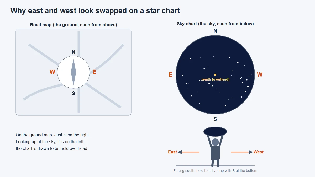
On a road map, east is on the right. On a sky chart, east is on the left.
This is not a mistake.
A road map shows the ground as you look down on it, while a sky chart shows the sky as you look up at it.
If you lie on your back with your head to the north, east is on your left.
The fix is to hold the chart the way the sky really is.
Face the direction you want to observe and turn the chart so that the matching horizon label is at the bottom.
Facing south, south goes at the bottom; facing north, north goes at the bottom.
The stars near the lower edge will now appear near your real horizon, and those near the center will be high overhead.
Decoding Dots, Lines and Symbols
Charts pack a lot of information into small marks.
Check the legend first, because conventions vary between publishers, but most follow these patterns:
- Dot size shows brightness. Bigger dots mean brighter stars. The legend links each size to a magnitude, where lower numbers are brighter.
- Greek letters label stars. The brightest star in a constellation is often alpha, the next beta and so on, although the order is not always strict.
- Solid lines connect the stars of each constellation's figure. These stick figures are not official and differ from chart to chart.
- Dotted or faint lines may mark the official constellation boundaries.
- A dashed line often traces the ecliptic, the path of the Sun, along which the Moon and planets also travel.
- Shaded areas usually show the Milky Way.
- Special symbols mark deep-sky objects, commonly a dotted circle for an open cluster, a circle with a cross for a globular cluster, an oval for a galaxy and a square or irregular outline for a nebula.
Setting the Date and Time Correctly
With a planisphere, rotate the disc until the time on the outer edge lines up with today's date.
Many planispheres are designed for standard time, so during daylight saving time subtract one hour from your clock before setting it.
Time zones add a further wrinkle.
A zone can be hundreds of miles wide, but the sky follows your true longitude,
so observers at the eastern and western edges of the same zone see the sky shifted by a noticeable amount at the same clock time.
For casual stargazing the difference rarely matters; for planning precise observations, an app will do the math for you.
Finally, remember what is missing.
The Moon and planets move against the stars, so most charts leave them out or show them only for a specific date.
A bright point near the ecliptic that is not on your chart is almost certainly a planet.
Measuring Distances on the Sky
Astronomers measure sky distances as angles.
The horizon to the zenith is 90 degrees, and the full Moon is only about half a degree wide.
Your hand, held at arm's length, makes a surprisingly consistent ruler because people with longer arms tend to have bigger hands.
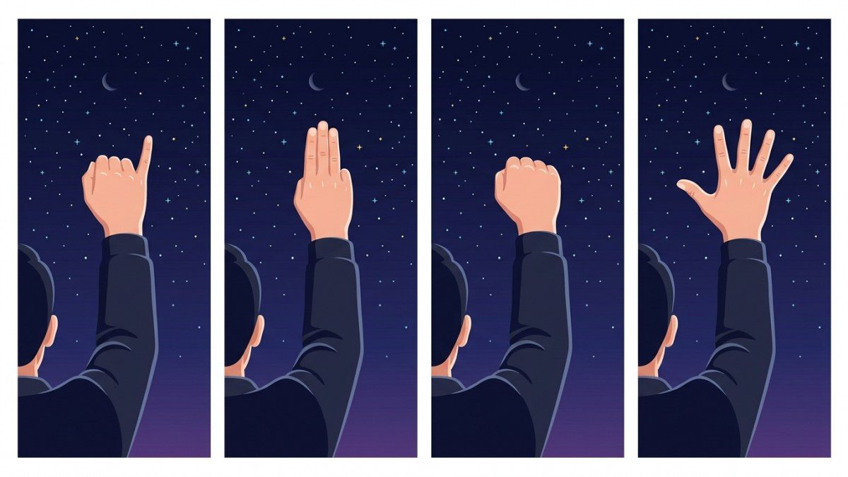
| Hand at arm's length | Approximate angle | Sky example |
|---|---|---|
| Tip of little finger | 1 degree | Two full Moons side by side |
| Three middle fingers | 5 degrees | The gap between the Big Dipper's Pointer stars |
| Closed fist | 10 degrees | The top edge of the Big Dipper's bowl, or the Southern Cross to its nearer Pointer |
| Outstretched hand, thumb to little finger | 20 to 25 degrees | About the length of the whole Big Dipper |
Measure a known pair of stars on the chart against the chart's scale, then compare with your hand outside.
Charts shrink the sky dramatically, and this step is what finally makes the page and the real sky feel the same size.
Celestial Coordinates Made Simple
Detailed charts show a grid of lines. It works like latitude and longitude projected onto the sky.
Declination is the sky's latitude, measured in degrees north or south of the celestial equator,
from plus 90 at the north celestial pole to minus 90 at the south.
Right ascension is the sky's longitude, measured eastward in hours, from 0 to 24, because the sky appears to turn once a day.
You do not need coordinates to enjoy the sky, but they tell you useful things.
An object's declination shows whether it ever rises from your latitude,
and its right ascension tells you which season it is best placed in the evening.
Put It Into Practice With a First Star-Hop
Star-hopping means moving from a bright star you know to a fainter target, one small step at a time,
using patterns on the chart. Try this classic Northern Hemisphere hop on an autumn evening:
- Find the Great Square of Pegasus, four moderately bright stars forming a large box.
- From the corner star nearest Cassiopeia, follow the curved chain of stars leading away from the square and stop at the second fairly bright star along it.
- From that star, turn toward Cassiopeia and hop to a fainter star, then to a second, even fainter one just beyond it.
- Just past that second faint star, look for a soft, elongated glow. That is the Andromeda Galaxy.
In the Southern Hemisphere, start with the Southern Cross.
Beside Mimosa, its second-brightest star, binoculars show the Jewel Box, a small sparkling cluster,
while the dark patch next to the cross is the Coalsack,
a cloud of dust blocking the Milky Way behind it.
Frequently Asked Questions
Can I use a Northern Hemisphere chart in the Southern Hemisphere?
A planisphere or all-sky chart made for northern latitudes will show the wrong horizon and leave out much of the southern sky,
so get one made for your latitude. A star atlas, which maps the whole sky, works anywhere.
Why do red markings vanish under my red flashlight?
Red ink reflects red light about as well as white paper does, so it disappears.
Some charts print features in red for this reason.
If yours does, carry a small white light for planning and a dim red one for use in the field.
Why does the sky look so much bigger than the chart?
A chart squeezes half the sky onto a sheet of paper.
Use hand measurements to rescale it in your head, and start with bright patterns that span many degrees before hunting for small ones.
Clear Skies Ahead
Reading a star chart is a skill that grows quickly with practice.
Hold it the right way, check the legend, set the correct time and measure with your hand.
After a few star-hops, the chart stops being a puzzle and becomes the quickest way to explore the sky.
Sources and Further Reading
This article was reviewed by the LoudComet editorial team against the official sources below. Mission details and sky events change over time, so check the agencies' own pages for the latest information.
- Make a Star Finder, NASA Space Place: Hold the chart overhead and turn it so its horizon edges match the real directions; charts suit one latitude and shift an hour in daylight time.
- The Constellations, International Astronomical Union: The 88 constellations are sky areas with official boundaries; the stick figures joining their stars are not officially defined.
- Magnitudes, Globe at Night (NSF NOIRLab): The magnitude scale runs backward: lower numbers are brighter stars, and darker skies reveal fainter ones.
- Astronomy without a telescope: what can I see in the night sky?, Royal Museums Greenwich (Royal Observatory): Using a planisphere or an app with a red filter, a red torch to protect night vision, and giving your eyes time to adapt.